Thursday, May 8, 2008
No. 141 - Chatsworth Reservoir Kiln Site
Chatsworth Reservoir Kiln Site
c. 1800
Southeast from the Intersection of Woolsey Canyon Road and Valley Circle Boulevard, Chatsworth – map
Declared: 4/2/75
Welcome to Chatsworth, the Land Of Historic-Cultural Monuments You’re Not Really Allowed To Get To.
HCM No. 142 is a centuries-old kiln used for burning limestone in the making of lime for concrete, mortar, and whitewash, a step in the construction of bricks and tiles, most notably by Indians for the nearby San Fernando Mission. The spot was ideal for a kiln operation, the area being rich in oak trees and with a good amount of lime deposits. It’s estimated that, at one time, there were as many as five kilns like this in the area. By the time our kiln was landmarked in the mid-seventies, it had already been the subject of serious wear and tear. (It’s thought, prior to the monument’s designation, a backhoe may’ve obliterated the kiln’s vents, arches, and flues. Something did, at any rate.)
The kiln, also known as the Chatsworth Calera (calera is Spanish for “limestone quarry” or “limekiln”), is basically a hole in the ground with walls of vitrified limestone and brick. It measures about fifteen feet deep and six and a half feet across.
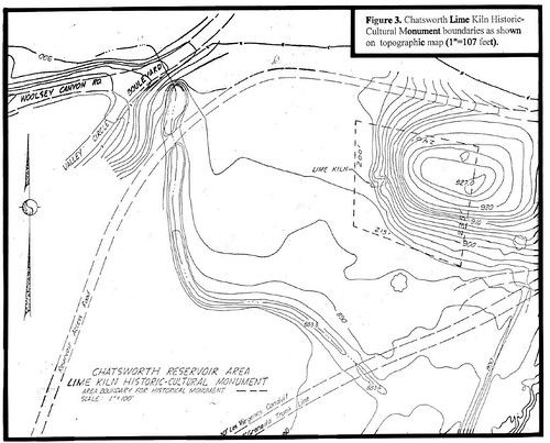
Incredibly, the site of the former, larger Chatsworth Reservoir, drained in 1969, remains free of development. For the latest on plans for the old reservoir’s future, read A Cultural Resources Study for the Proposed Wetland Riparian Restoration Program at Chatsworth Reservoir, Chatsworth, Los Angeles County (don’t worry, it’s not much longer than its title). A study from this past March 25 by Robert S. White, Laura S. White, M.A., and David M. Van Horn, Ph.D. through Santa Barbara’s John Minch & Associates, Inc., it’s from where are I pulled this handy map of the site.
Honestly, I’m not convinced the map above jibes with the actual site all that well. According to the map, the kiln would lie about 400 feet from the intersection of Woolsey Canyon Road and Valley Circle Boulevard. That’s 1.33 football fields, about half a football field more than at which I would’ve guessed the distance.
The plan to preserve forty-four acres of the 1,318 Chatsworth Reservoir property as riparian and wetland habitats by Browning-Ferris Industries is in exchange for the company's destroying habitats through its landfills near Sylmar.
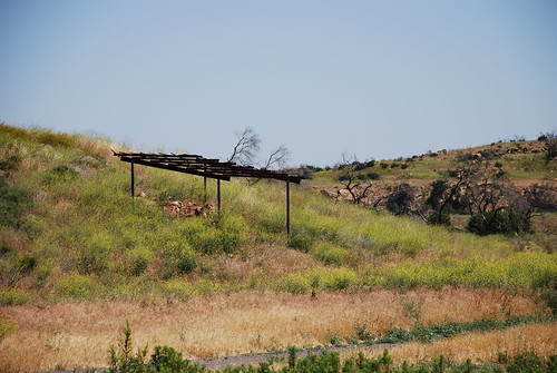
The report says the old kiln is in need of stabilization. It also recommends the recently burned lean-to be reconstructed and enlarged.
Chatsworth is in the middle of a monument crisis. No. 92, the Old Stagecoach Trail, and No. 133, the Minnie Hill Palmer House and Dynamite Shed, are currently off limits due to Chatsworth Park South being shut down for its soil’s ongoing lead tests. On the positive side, while access to No. 142 is limited to L.A. DWP workers, you can still see a bit of the old kiln and that burned lean-to from where Woolsey Canyon Road and Valley Circle Boulevard meet.
Up next: Smith Estate


Wow-
ReplyDeleteI grew up in Chatsworth and didn't know about this. Guess that feeds into your "not allowed" title.
I moved to the lake area in 1969 and do remember in the 70's there was restoration activities at the kiln and it is exactly were the map show it, you can see the site clearly on Google Earth. its always been behind D.W.P. fence so no one can get to it.
ReplyDeleteThis site is in West Hills, actually.
ReplyDelete